
|
|
Gas Well (and more) Locating Maps, Mapping Tools
Mapping Viewers to locate oil, gas and injection well sites or permitted sites in Ohio and nationally. Some will provide a pop-up box giving further information, location, link, for the well:
Frac Tracker - extensive tools for Ohio and Pennsylvania http://maps.fractracker.org/latest/?webmap=4e21676b1c00414ba14edf654c7f7fe3
Use link http://www.marcellus.psu.edu/images/permit_animation.gif to view an animated map of Pennsylvania revealing the number of Marcellus Shale Drilling Permits issued for each separate year from 2007 thru 3/21/2012.
Deep Injection Wells in Pennsylvania: http://stateimpact.npr.org/pennsylvania/maps/location-of-deep-injection-wells-in-pennsylvania/
ALSO see: http://stateimpact.npr.org/pennsylvania/2011/09/22/burning-question-where-are-pas-deep-injection-wells/
Horizontal Marcellus Shale Well Activity in Ohio [1.0 MB PDF] Updated 02/14/2012: http://www.dnr.state.oh.us/Portals/10/Energy/Marcellus/MarcellusWellsActivity_02142012.pdf
Map of Horizontal Utica-Pt. Pleasant Well Activity in Ohio [1.8 MB PDF] Updated 04/09/2012 http://www.dnr.state.oh.us/portals/10/Energy/Utica/UticaWellsActivity_04092012.pdf
Class II Injection Wells in Ohio http://www.communitywalk.com/class_ii_injection_wells_in_ohio/map/1470983
Injection Well Violations map showing the injection wells in Ohio that have had violations since 2000 http://www.communitywalk.com/injection_well_violations/map/1472118
Map of Class II Brine Injection Well Sites in Ohio (website) http://www.ohiodnr.com/mineral/injection/tabid/10374/Default.aspx
Map of Class II Brine Injection Well Sites in Ohio (PDF image) http://www.dnr.state.oh.us/Portals/10/pdf/ClassIIWellsMap.pdf
Class II Injection Wells in Ohio article with links http://www.plunderbund.com/2012/01/14/are-they-dumping-fracking-wastewater-in-your-town/
Class II Injection Well Data Sheet List of Injection Disposal Wells in Ohio as of 01/01/2012 http://www.scribd.com/doc/78287656/Injection-Well-Data-Sheet
Ohio Disposal Wells map by Cleveland Channel 5 News: http://www.newsnet5.com/generic/news/local_news/investigations/ohio-disposal-wells-interactive-map
Permits issued by ODNR for horizontal drilling in Ohio shale (Utica) as of 4/16/2012 (website) http://innovationohio.org/fracking-map
Ohio Shale Drilling Locations - As of 4-16-2012 (MAP) http://maps.google.com/maps/ms?msa=0&msid=216331406916473145360.0004be13117fe6b1df8bb&ie=UTF8&t=m&ll=40.53466,-81.496884&spn=1.748129,1.935&source=embed
Ohio Division of Geological Survey Web-based mapping systems (7 kinds) including Oil & Gas Well Locations, and, Emergency Oil and Gas Well Locator http://www.dnr.state.oh.us/OhioGeologicalSurvey/tabid/23583/Default.aspx
Ohio Division of Geological Survey Oil and Gas Field and Wells Interactive Mapping Launch Page http://www.dnr.state.oh.us/tabid/7950/Default.aspx
Ohio Division of Geological Survey Emergency Oil & Gas Well Locator Map http://www.dnr.state.oh.us/Website/Geosurvey/geosurvey_emergency_oilgas/viewer.htm
Ohio Division of Geological Survey Oil & Gas Well Locations http://www.dnr.state.oh.us/tabid/7950/Default.aspx
Ohio Division of Geological Survey Ohio Earthquake Epicenters http://www.dnr.state.oh.us/tabid/8104/Default.aspx
Ohio Division of Geological Survey Abandoned Underground Mines http://www.dnr.state.oh.us/tabid/8101/Default.aspx
Ohio Division of Geological Survey Marcellus and Utica Shales Data Files to download: http://www.dnr.state.oh.us/tabid/23014/Default.aspx
Frac Sand Mine and processing plant sites compiled in July 2011 (Wisconsin) (website) http://www.wisconsinwatch.org/2011/07/31/frac-sand-wisconsin-sites/
Frac Sand Mine and processing plant sites compiled in July 2011 (Wisconsin) (PDF image) http://www.wisconsinwatch.org/wp-content/uploads/2011/07/Frac-sand-sites.pdf
Frac Tracker Resources http://www.fractracker.org/resources/tutorials/
The People's Reporting Registry Map, Erin Brockovich data project, View or report harmful effects (stage one) http://www.brockovich.com/peoplesreportingregistrymap.html
Ohio People's Fracking Tracking Mapping: Find wells, reports, actions, photos, file a report: https://ohfrackmap.crowdmap.com/
Pennsylvania injection well locations (permitted ones not shown): http://stateimpact.npr.org/pennsylvania/2011/09/22/burning-question-where-are-pas-deep-injection-wells/
Pennsylvania oil and gas and water atlas (layer tools) : http://maps.psiee.psu.edu/paatlas/
Pennsylvania shale gas play active wells: Use this tool to learn which operators are drilling, and where. Find active wells in your county or municipality — and see whether the drillers have been cited for violating state environmental regulations: http://stateimpact.npr.org/pennsylvania/drilling/
FracFocus well site mapping tool of wells through January 1, 2011 and maybe others: http://www.hydraulicfracturingdisclosure.org/fracfocusfind/Map.aspx All FracFocus well site information is voluntarily provided by participating oil and natural gas operators. Wells hydraulically fractured after January 1, 2011 will be added to the database over time.
Locations around Kent, Ohio, of all the fracking related processes - updated continually:
View Fracking sites around Kent in a larger map
View Fracking sites around Kent in a larger map
Un-annotated MAPPING links
Wisconsin geology map (JPEG Image, 1200 × 1250 pixels)
History & Social Geography Map ::: Journey Up Coal River
RPIS - Regional Property Information System
Snapshot: Abandoned wells and Unconventional Wells
Fracking Across the United States | Earthjustice
City Lights of the United States 2012 : Natural Hazards
Fracking Chemical Database - SkyTruth Drilling Alerts
WRP Project Location Map
Fracking Map
Shale Energy Interactive Map
Ohio Shale Gas Viewer
Ohio Shale Drilling Locations - As of 4-16-2012 - Google Maps
PA Atlas SaveOURStreams
Burning Question: Where Are PA's Deep Injection Wells? | StateImpact Pennsylvania
Shale Play: Natural Gas Fracking in Pennsylvania | NPR StateImpact: Issues That Matter. Close To Home.
EQT Production | Shale Play: Natural Gas Fracking in Pennsylvania | NPR StateImpact: Issues That Matter. Close To Home.
ECharts_Shale-Plays-Map_HiRes.jpg (JPEG Image, 1650 × 1280 pixels) - Scaled (70%)
My Waterway
ArcGIS - Injection Wells
US_CanadaGasPipelineRoutes-full.png (PNG Image, 1600 × 951 pixels)
BLM_SMA_1mil_State_2011_508.pdf (application/pdf Object)
Erin Brockovich The People's Reporting Registry Map
Fractured Future: NB Shale Gas Rights Map
Class II Injection Wells in Ohio - CommunityWalk
Injection Well Violations - CommunityWalk
Class II Injection Wells in Ohio - CommunityWalk
Class II Injection Wells in Ohio - CommunityWalk
Ohio "fracking" wells map database | Coshocton Tribune | coshoctontribune.com
Ohio Geological Survey Interactive Maps Selection Page
ClassIIWellsMap.pdf (application/pdf Object) bdrkupyld.pdf (application/pdf Object)
MapViewer emergency
MapViewer oil&Gas
Oil and Natural Gas Well and Shale Drilling Resources - Ohio DNR Division of Mineral Resources Management
Water Withdrawal Atlas
Utica and Marcellus Formations Data and Maps
ODNR Division of Water Maps
Ohio Watersheds and Drainage Basins Maps
Oil and Gas Fields and Wells - IMS Disclaimer/Launch Page
Ohio Potentiometric Surface Maps County Download List
Ground Water Resources Maps for Ohio Images Download Page
SAMP Map Image Gallery
Map of Health Issues Reported Near Oil, Gas, Power Plant Energy Sites
Graphically Speaking: Fracking and Injection Wells | Energy From Shale
ESER
Frack Alert | Gas Drilling Accidents Pennsylvania
Oil & Gas Mapping Tools for United States Lands - Frackfree America National Coalition
Chemical Disclosure - Well Map
PA-Wastewater-Plants.pdf (application/pdf Object)
Permits_all.gif (GIF Image, 1000 × 648 pixels)
Wells-all.gif (GIF Image, 1000 × 648 pixels)
Napalm Creek -wellpermits
Natural gas drilling and data maps
Maps - Ohio
Underground Injection Control (UIC) - Ohio DNR Division of Mineral Resources Management
Interactive Oil & Gas Shale Map - Oil and Gas Help
Online Mapping
[UPDATED] Are they dumping fracking wastewater in your town?
http://www.relativevorticity.info/webmaps/frack.html
Injection Well Data Sheet
shalesheet.com - Shale Map
Gas Flare Observations
GIS Maps & Data Atlas
Water Resource Portal
Maps: The States Where Fracking Can Happen in Secret - Climate Desk - The Atlantic
Utica Shale: Drilling Permits
Maps | Alliance for Watershed Action and Resource Education
WellWatch
Frac sand: Wisconsin mines and plants | WisconsinWatch.org
frac-sand-sites-700px.jpg (JPEG Image, 700 × 1065 pixels) - Scaled (81%)
Frac-sand-sites.pdf (application/pdf Object)
The Mahoning River Watershed - Map Index
The Mahoning River Watershed - Glossary Index
The Mahoning River Watershed - Map Index
Gas Flaring Observations
Ohio Fracking Map - Google Maps
Fraccidents Map - Google Maps
Ohio Gas & Injection Wells- Google Maps
Fractivists - Google Maps
Fracking sites of Portage County, Ohio
Allegheny National Forest well pads north of Kane, PA - Google Maps
Maps & Well Inventory - Lawrence & Mercer ALLARM
Marcellous Shale Well Sites - Lawrence & Mercer ALLARM
NPMS Public Map Viewer
PA DEP Oil & Gas Reporting Website - Statewide Data Downloads By Reporting Period
PA DEP Oil & Gas Reporting Website - Statewide Data Downloads By Reporting Period
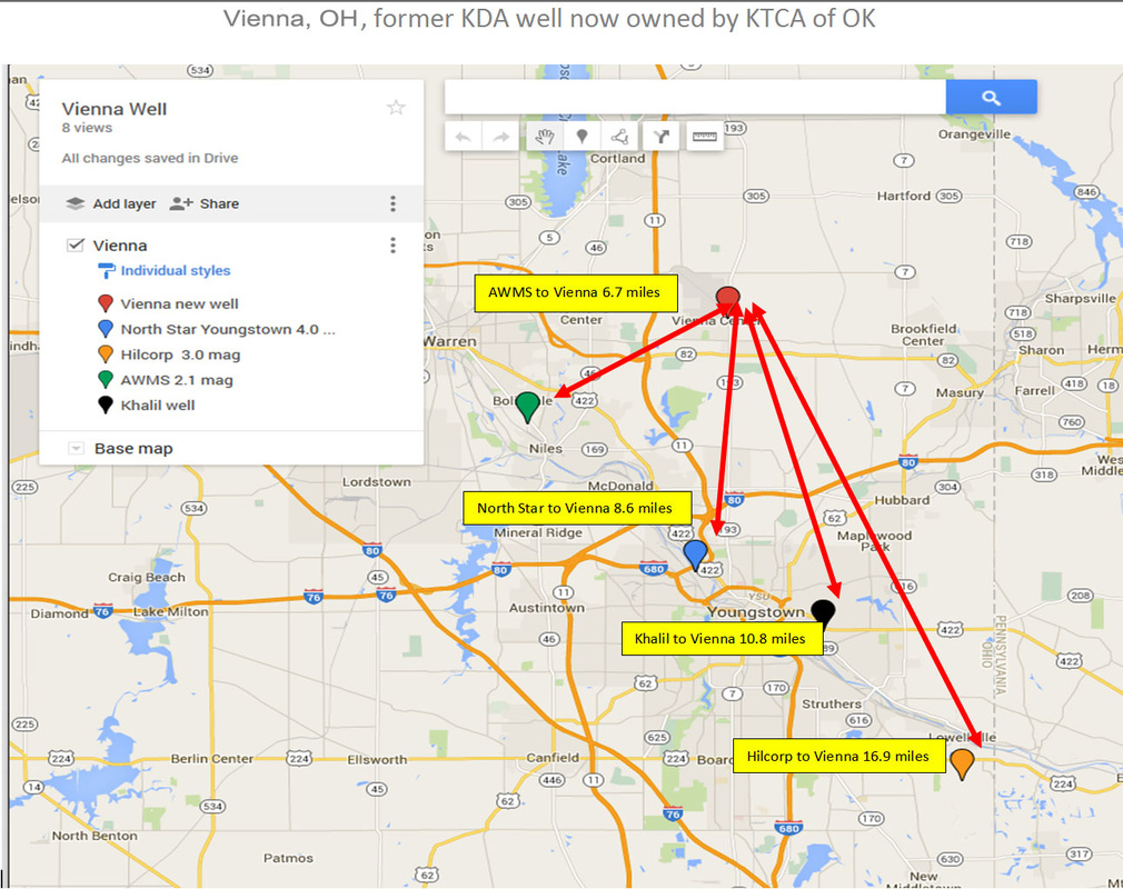
Seismically active areas near Vienna, OH former KDA injection well now owned by KTCA of OK
| seismic-active-wells-ne-ohio-vienna.pdf |
