
|
|
CNX Well Public Comments Taken from Board Meeting 3/14/13, Mahoning County Commissioners, Youngstown, Ohio, where Tom Hill, regional supervisor for the Ohio Department of Natural Resources, apprised the Board of Mahoning County Commissioners Thursday on the well and its operations.
14 public comments and ODNR replies: http://oilandgas.ohiodnr.gov/citizens/public-comment#CNX
- including a reworded version of the original documents posted here:
http://oilandgas.ohiodnr.gov/portals/oilgas/pdf/comment/CNX/CNX_Mahoning-7_Summary.pdf
Drilled:
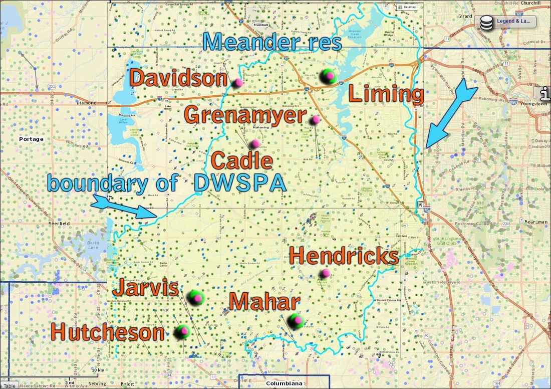
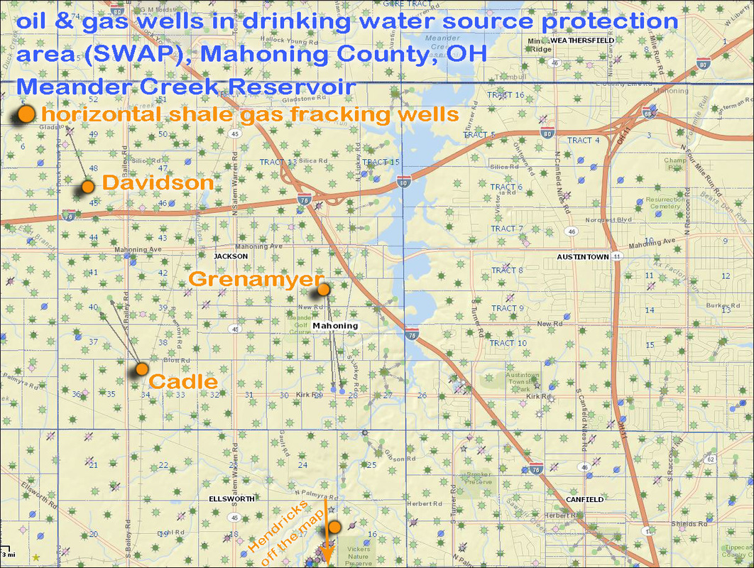
Davidson - #34099231880000 -- 13053 Silica Rd, North Jackson, Ohio 44451
Grenamyer - #34099232010100 -- 9686 New Rd, North Jackson, Ohio 44451, northeast of Meander Golf Course
Cadle - #34099231820100 -- 12175 Blott Rd, North Jackson, Ohio 44451, just east of Bailey Road
Hendricks - #34099231720100 -- 9360 W Western Reserve Rd, Canfield, Ohio 44406 , just south of Diamondback Golf Course
NOT drilled:
Liming - #34155240870000 -- 523 Yerke-Young Rd, Mineral Ridge, 44440 (just west of Austintown-Warren Road)
Jarvis #34099231700000 -- 14524 W Calla Rd, Salem, Ohio 44460
Mahar #34099231740000 -- 10300 W Middletown Rd, Salem, Ohio 44460
Hutcheson #34099231640000 -- 10313 Seacrist Rd, Salem, Ohio 44460
14 public comments and ODNR replies: http://oilandgas.ohiodnr.gov/citizens/public-comment#CNX
- including a reworded version of the original documents posted here:
http://oilandgas.ohiodnr.gov/portals/oilgas/pdf/comment/CNX/CNX_Mahoning-7_Summary.pdf
Drilled:
Davidson - #34099231880000 -- 13053 Silica Rd, North Jackson, Ohio 44451
Grenamyer - #34099232010100 -- 9686 New Rd, North Jackson, Ohio 44451, northeast of Meander Golf Course
Cadle - #34099231820100 -- 12175 Blott Rd, North Jackson, Ohio 44451, just east of Bailey Road
Hendricks - #34099231720100 -- 9360 W Western Reserve Rd, Canfield, Ohio 44406 , just south of Diamondback Golf Course
NOT drilled:
Liming - #34155240870000 -- 523 Yerke-Young Rd, Mineral Ridge, 44440 (just west of Austintown-Warren Road)
Jarvis #34099231700000 -- 14524 W Calla Rd, Salem, Ohio 44460
Mahar #34099231740000 -- 10300 W Middletown Rd, Salem, Ohio 44460
Hutcheson #34099231640000 -- 10313 Seacrist Rd, Salem, Ohio 44460
Fracking natural gas wells once permitted in protected drinking water area - permits of 4 have expired as of August 2015.

(Click to view larger) Permits and other records for the Cadle - MAHN7AHSU well # API Well Number API# 34099231840000
Links in the above record are:
1) http://www.dnr.state.oh.us/Website/Geosurvey/OILGAS/WellSummaryCard.asp?api=34099231820000
2) http://www.dnr.state.oh.us/Website/Geosurvey/OILGAS/WellSummaryCard.asp?api=34099231840000
3) http://www.dnr.state.oh.us/Website/Geosurvey/OILGAS/WellSummaryCard.asp?api=34099231830000
4) http://www.dnr.state.oh.us/Website/Geosurvey/OILGAS/WellSummaryCard.asp?api=34099231820100
NOTE the numerous undistinguished links at the bottom of each well permit record.

FIGURE 1 (Click to view larger) Lateral legs of the Cadle - MAHN7AHSU wells (2 wells) # API Well Number 34099231840000
ODNR map:
https://gis2.ohiodnr.gov/arcgis/rest/directories/arcgisoutput/Utilities/PrintingTools_GPServer/_ags_f1b2344ebff743d58ae56229b410e598.pdf
ODNR map:
https://gis2.ohiodnr.gov/arcgis/rest/directories/arcgisoutput/Utilities/PrintingTools_GPServer/_ags_f1b2344ebff743d58ae56229b410e598.pdf
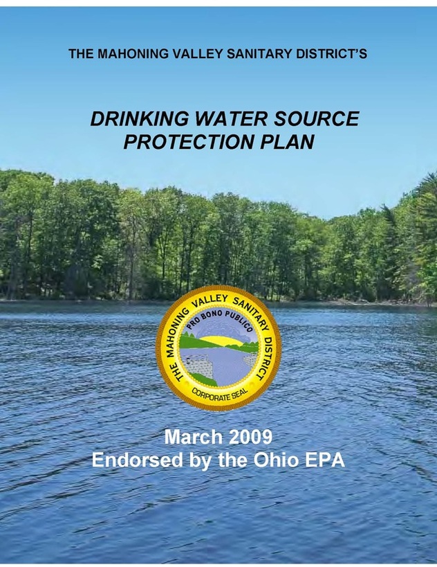
FIGURE 2 Click cover image to view MVSD (MAHONING VALLEY SANITARY DISTRICT) surface water source Management Plan for industries located in the drinking water source lands. (or use link: http://meanderwater.com/Portals/MeanderWater/Documents/MVSD%20DWSPP%20EPA%20Endorsed.pdf )
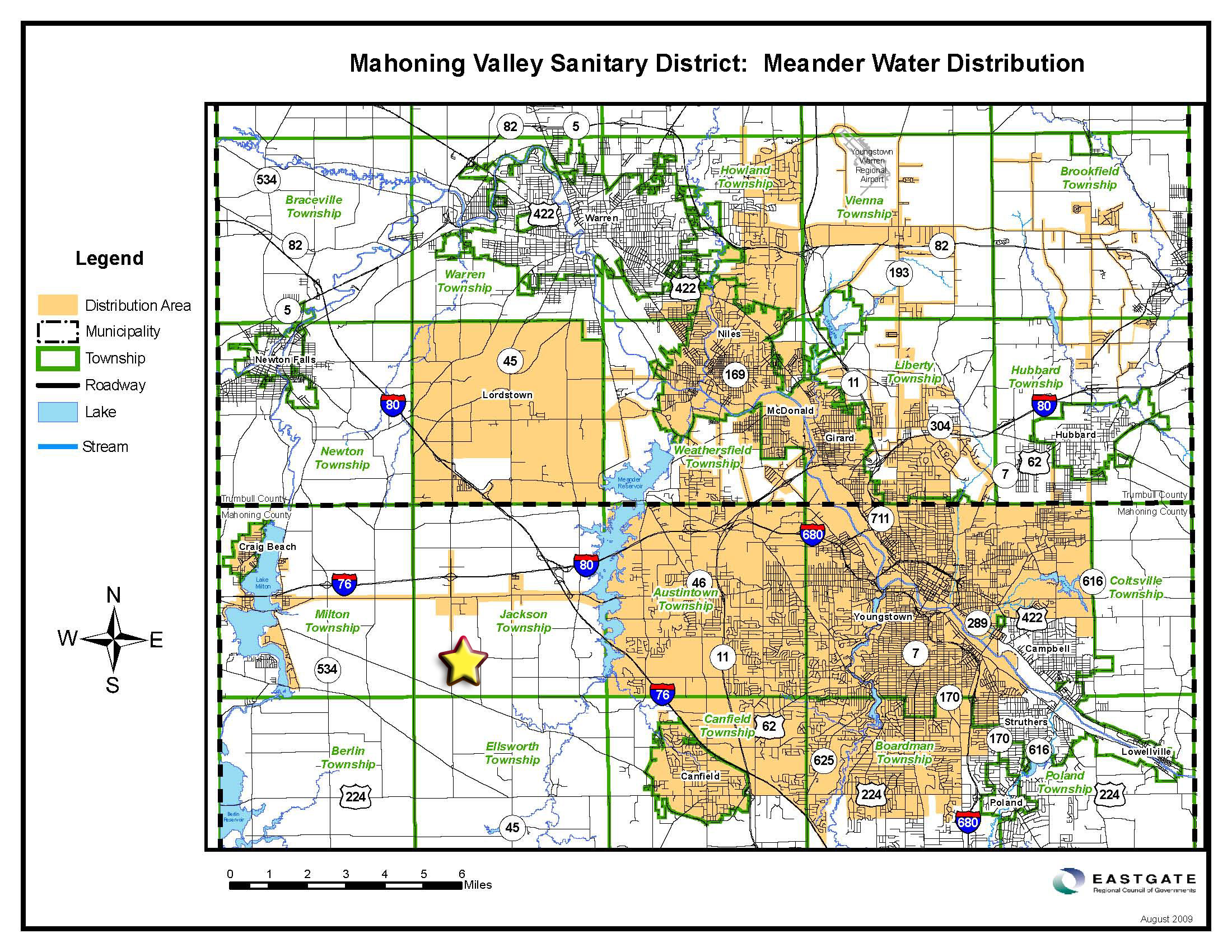
FIGURE 3 (Click to view larger) Meander Reservoir drinking water distribution (click image to enlarge) Gold star marks the Cadle - MAHN7AHSU well - located in drinking water source protection area for the MVSD (Mahoning Valley Sanitary District)

FIGURE 4 (Click to view larger) Communities of the Meander Creek watershed (click image to enlarge) Gold star marks the Cadle - MAHN7AHSU well and orange star marks the Henricks MAHN-2 well, both located in drinking water source protection area for the MVSD (Mahoning Valley Sanitary District)
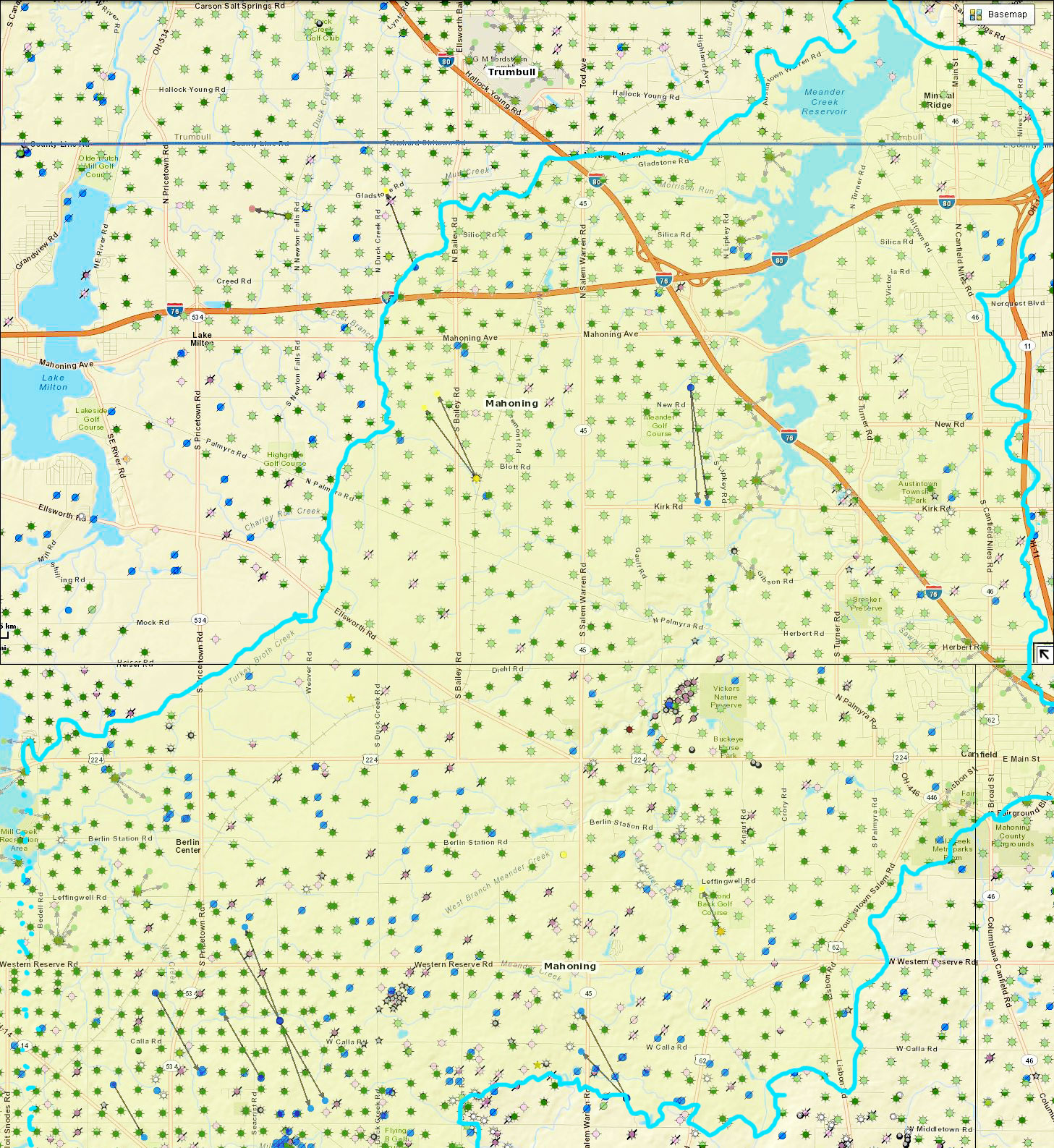
Latest Utica shale well permits and drilled wells in Mahoning County.
More mapping tools here: http://www.uticashaleblog.com/p/maps.html
and HERE mapping tools
More mapping tools here: http://www.uticashaleblog.com/p/maps.html
and HERE mapping tools
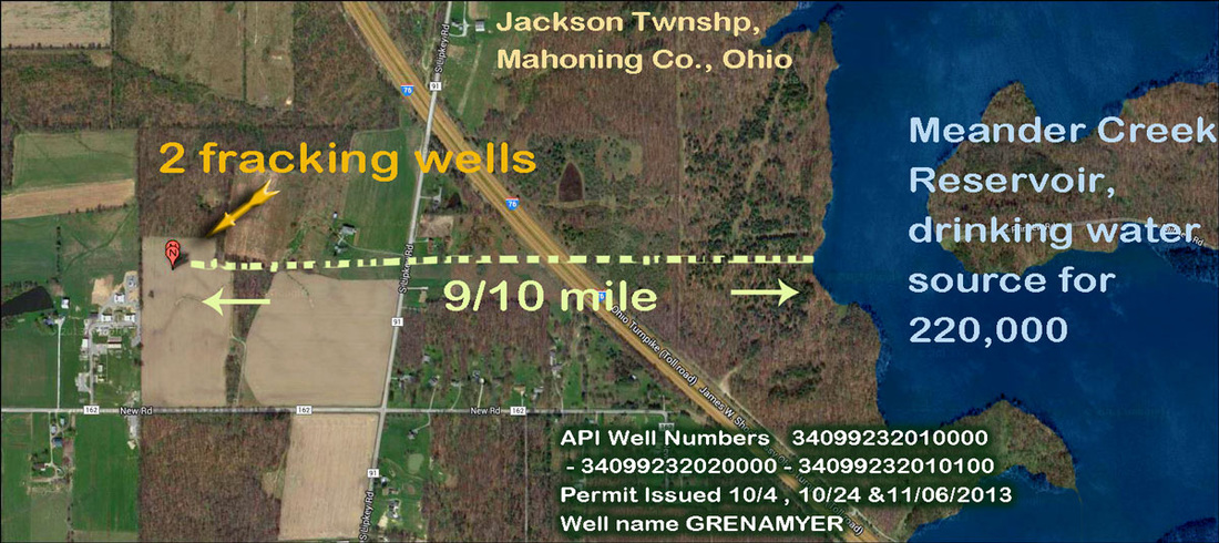
Two of the latest Utica shale well permits and drilled wells in Mahoning County - less than a mile from the drinking water reservoir itself.
More mapping tools here: http://www.uticashaleblog.com/p/maps.html
and HERE mapping tools
More mapping tools here: http://www.uticashaleblog.com/p/maps.html
and HERE mapping tools
v
Num
download larger 700 K file 1457 X 1587
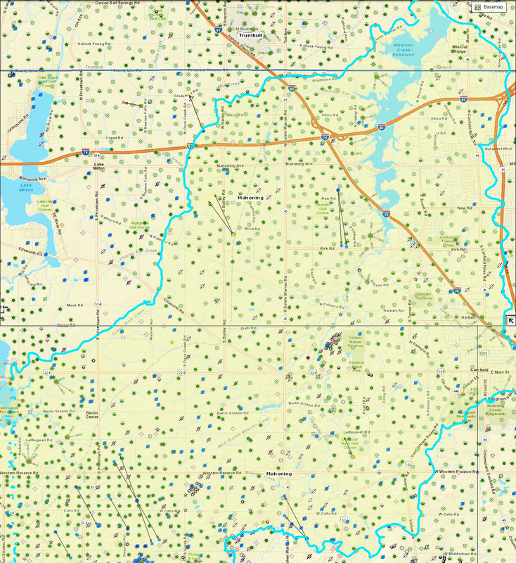
Number of gas and oil wells in the Drinking Water Source Protection Area (DWSPA) [blue outline w/ light green shading], (protection area) DWSPA for an inland stream is defined as the drainage area upstream of the point where the water is withdrawn from a surface source such as a stream, lake or reservoir. The protection area for the MVSD Meander Creek Reservoir is fan-shaped and encompasses 86.5 square miles. The protection area is subdivided into a corridor and an emergency management zone.
The Corridor Management Zone, (CMZ) is the area within 1,000 feet of each bank of Meander Creek Reservoir, starting from the intake and extending to a point approximately 4 miles upstream of the reservoir, a distance of approximately 10 miles from the intake. The corridor management zone also includes tributaries of Meander Creek Reservoir. On tributaries the width of the corridor management zone is 500 feet from each bank. The length of the corridor management zone on a tributary is 10 stream miles from the intake. For example, a tributary four miles in length that enters the reservoir six miles upstream of the intake would be completely within the corridor management zone. A tributary stream entering eight miles from the intake would have only two miles of its stream length within the corridor management zone. - from 2009 report at http://meanderwater.com/Portals/MeanderWater/Documents/MVSD%20DWSPP%20EPA%20Endorsed.pdf

FIGURE 5 (Click to view larger) Gold star marks the Cadle - MAHN7AHSU well - located in drinking water source protection area for the MVSD (Mahoning Valley Sanitary District) - the grey area
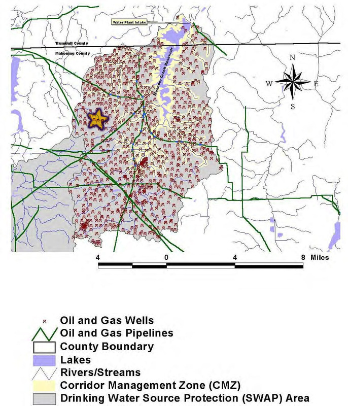
FIGURE 6 (Click to view larger) Conventionally drilled vertical Clinton oil & gas wells already located in the protected area.
Gold star marks the unconventional high volume horizontally drilled fracked Cadle - MAHN7AHSU well - located in drinking water source protection area for the MVSD (Mahoning Valley Sanitary District) - the grey area.
This image is from the earlier 24 pp. 2003 Report which can be read in its entirety HERE:
http://planning.co.trumbull.oh.us/_source%5CComprehensive%20Planning%5CSource%20Water%20Protection%20Plans%5CMVSD%20SWAP.pdf
The same images are included in the 2009 Report but it is 154 pp and takes longer to download: may be downloaded HERE: http://meanderwater.com/Portals/MeanderWater/Documents/MVSD%20DWSPP%20EPA%20Endorsed.pdf
Fracking wells on banks Meander Creek drinking water reservoir - protected drinking water area arrayed with many venues for communication
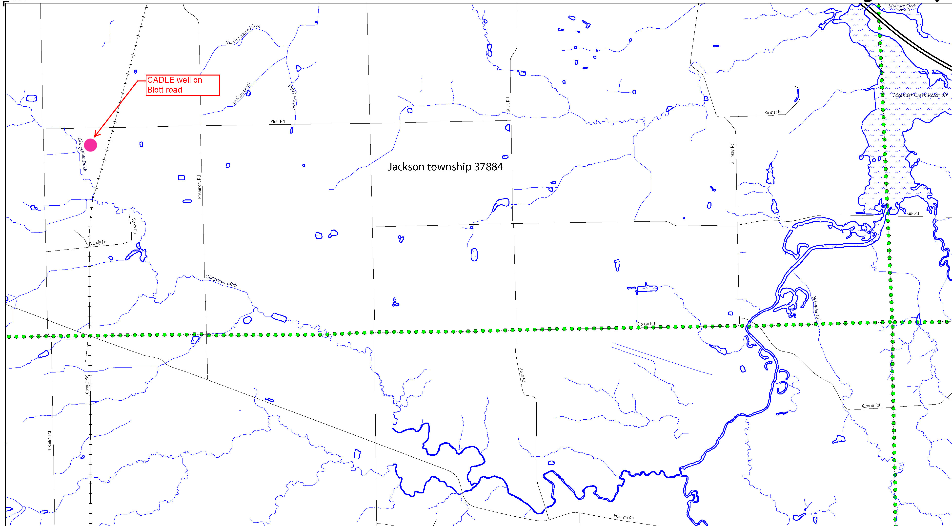
FIGURE 7 (Click to view larger) Path of the fresh water flowing past the Cadle - MAHN7AHSU well - in drinking water source protection area for the MVSD (Mahoning Valley Sanitary District) into the Meander Creek reservoir. Pink dot marks the well pad with 2 wells.
*UPDATE*:
2010 CNX drilling violation that occurred in Belmont County, Ohio: specifically:
1) Drilling operation causing pollution and contamination
2) Dike or pit not able to prevent escape of Brine or other waste
See PDF file in viewer below:
OR HERE (click) if SCRIBD-Weebly viewer interface is not cooperating.
| CNX 2010 drilling violation compliance notice (PDF file) (click to download/view) |
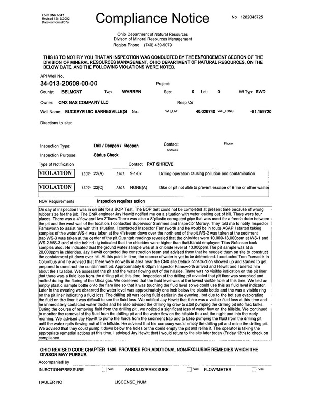
Click to enlarge page 1 of 2
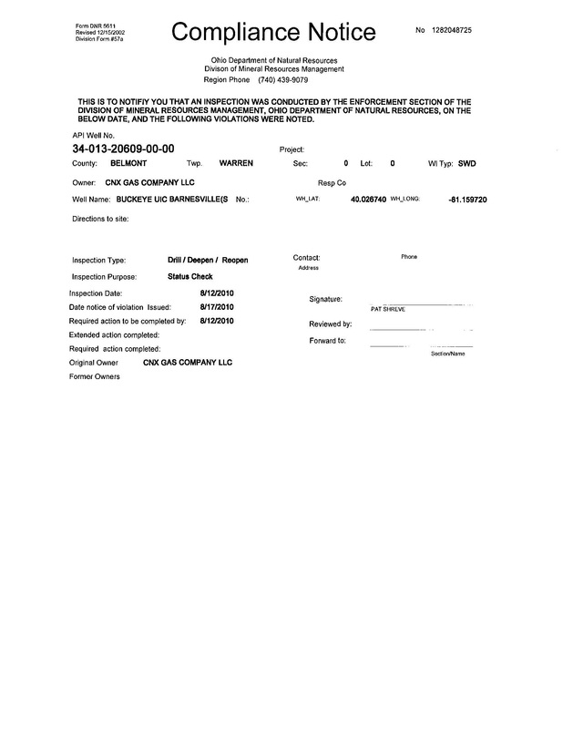
Click to enlarge page 2
|
| ||||
Protect your drinking water!
|
Protect your drinking water!
|
